Fire Health & Safety, Wildfire Articles
Fire Pit Safety Tips
Stay safe around the campfire with tips from the Western Fire Chiefs Association. Learn essential precautions and practices for a worry-free outdoor campfire.
Explore details regarding the Texas fire season from the Western Fire Chiefs Association (WFCA). Learn when is it, how long it lasts, risk factors, and more.
Published:April 26, 2023
Edited:April 24, 2024
Explore details regarding the Texas fire season from the Western Fire Chiefs Association (WFCA). Learn when is it, how long it lasts, risk factors, and more.
Texas is the second-largest state in the U.S. in terms of both size and population, and it contains a huge range of environments and terrain. Wildfires are a rising concern in the state as they grow in intensity and impact. Learn about Texas’ wildfire season and the risks that residents may face in the future.
Climate change has extended fire season in Texas to run year-long, but wildfire risk is more severe in the winter (February through April) and the summer (August through October).1 The winter fire season, also called the dormant fire season, is caused by cold fronts bringing dry air to the state, while the freeze-cured grasses and high winds increase wildfire intensity.2 The summer wildfire season is due to high heat and extended drought conditions.
Wind, the dryness of the ground due to drought (also called surface dryness), and low humidity all create wildfire risk conditions in Texas. High winds cause wildfire to spread faster and further, and can contribute to drought conditions as they dry out air and fuels in an area. Texas is at risk of wildfires any time there are three to four consecutive weeks of high winds and drought.3
Weather patterns are a major factor in determining Texas’ yearly wildfire risk. In the Pacific Ocean, trade winds follow the equator and travel west, taking warm water from South America towards Asia. Two climate events break this pattern: El Niño and La Niña. These events take place approximately every two to seven years and usually last 9-12 months, but they do not have a regular schedule and can last for years.4
During La Niña years, winter conditions in Texas are warmer and drier than normal. This increases the risk of extreme wildfires, especially in the Southern Plains area of the state. A Southern Plains Wildfire Outbreak (SPWO) occurs when there are west-southwest winds across an area with low humidity, higher than average temperatures, dry vegetation, and clear skies. Wildfires in a SPWO event often grow quickly and are difficult to control; 18 of the 30 largest wildfires in Texas occurred under SPWO conditions.5 High winds create dangerous wildfire growth and contribute to extreme fire behaviors.
While droughts create an obvious fire risk as they dry timber, brush, grass, and surface vegetation, there is also risk when growing seasons are wetter than average in Texas. Persistent drought limits the amount of grass that grows and leads to a reduced fuel load (the amount of debris available to burn). When wetter weather is followed by drought, the fuel load is higher and there is more risk of an intense fire season.6 Areas of Texas are also at high risk for wildfire due to fuel load because approximately 94% of the land is privately owned, and therefore managing vegetation is the responsibility of individual owners.7
Nearly 90% of wildfires are started by humans.8 The largest cause of wildfire ignition in Texas is when people burn debris. Other human-caused fires result from discarded smoking materials, sparks from welding and other industrial equipment, vehicle exhaust systems, and arson. To reduce wildfire risk, Texas residents can avoid burning debris on windy days, monitor any fire or flammable material until it is completely out, wet down the surrounding area before welding or using equipment that could spark, and take extra care when using equipment or driving/parking a vehicle in tall, dry grass. It is also important to keep fire extinguishing tools on hand.9
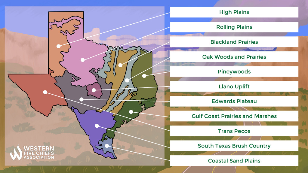
Texas is divided into 10 climate regions, from high plains and forests to the Gulf Coastal Plains’ marshes and humid marine prairies.10 In the semi-arid environments of the Southwest and the Great Plains, climate change is contributing to rising hot temperatures and decreasing precipitation.3 A 2020 report from the Texas State Climatologist’s Office predicts growing droughts and wildfires in the eastern area of Texas.11 Central Texas now experiences year-round wildfire risk.12
Texas’ increasing population, shifting weather patterns, and changes in land use are raising the risk of extreme wildfire damage impacting Texas communities. Over 85% of all wildfires ignite within two miles of a community and this number will grow as more people build homes in the wildland-urban interface.5 The high risk of wildfire damage to single-family houses in Texas is often because of dense foliage near homes.12
The largest fire in Texas in the 21st century was the East Amarillo Complex Fire during the winter fire season of 2006. It started in the Texas panhandle and burned 907,245 acres before it was contained.13 According to the Texas A&M Forest Service, the 2011 Texas fire season was the most devastating in terms of both the number of fires, acres burned, and the damage done. Nearly 3,000 homes were destroyed and nearly 4 million acres burned across the state.7
Texas experiences an average of 9,000 wildfires per year, though most burn only a few acres before they are contained.5 Below is a list of recent wildfires in Texas.
| Smokehouse Creek Fire (2024)22 Start Date: 02/26/2024 Location: Hutchinson County Acres Burned: 1,078,086 Cause: Under Investigation | |
| Bent Willow Fire (2023) Start Date: 4/4/2023 Location: Potter County Acres Burned: 8,118 Cause: Unknown | Loma Desert Fire (2023)14 Start Date: 4/4/2023 Location: Hudspeth County Acres Burned: 1,946 Cause: Unknown |
| Eastland Complex Fire (2022)15 Start Date: 3/15/2022 Location: Eastland and Brown Counties Acres Burned: 54,513 Cause: Under investigation | Borrega Fire (2022) Start Date: 3/30/2022 Location: Kleberg County Acres Burned: 51,566 Cause: Unknown |
| Texas Copper Breaks Fire (2019)16 Start Date: 8/16/2019 Location: Hardeman County Acres Burned: 7,206 Cause: Unknown | Mallard Fire (2018)17 Start Date: 3/8/2018 Location: Armstrong County Acres Burned: 75,530 Cause: Unknown |
| Perryton Fire (2017)18 Start Date: 3/6/2017 Location: Ochiltree, Lipscomb, Roberts, and Hemphill Counties Acres Burned: 318,156 Cause: Human (downed power lines or sparks from a transformer) | Lefors East Fire (2017) Start Date: 3/6/2017 Location: Gray and Wheeler Counties Acres Burned: 135,000 Cause: Unknown |
| Crutch Fire (2016)19 Start Date: 3/23/2016 Location: Carson, Hutchinson, Roberts, and Gray Counties Acres Burned: 44,686 Cause: Human (downed power lines) | Hidden Pines Fire (2015)20 Start Date: 10/13/2015 Location: Bastrop County Acres Burned: 4,582 Cause: Human (ranch equipment) |
Texas has diverse environments and unique wildfire mitigation challenges due to climate conditions, land use, and land ownership. Historical fire intervals in the state varied depending on terrain. For example, the pine forests in eastern Texas had late growing season fires at regular, short intervals, while the Blackland Prairies saw large burns every three to seven years, and the Rolling Plains in North Central Texas had fire intervals of 20-30 years.21 These wildfire intervals were disrupted by strict wildfire suppression practices throughout the 20th century. State organizations are working to promote revised, environment-conscious wildfire risk mitigation strategies for private landowners.
Utilize WFCA’s Fire Map to search for the status of an active wildfire in Texas. Users can zoom in and select each individual fire to get instant access to the latest published information.
Stay safe around the campfire with tips from the Western Fire Chiefs Association. Learn essential precautions and practices for a worry-free outdoor campfire.

Discover essential firework safety tips to ensure a dazzling display without accidents. Learn how to celebrate responsibly with expert guidance from WFCA.
Explore the role of AI in wildfire prediction with guidance from the WFCA. Learn how advanced algorithms and data analytics enhance early detection and response.