Fire Health & Safety, Wildfire Articles
Fire Pit Safety Tips
Stay safe around the campfire with tips from the Western Fire Chiefs Association. Learn essential precautions and practices for a worry-free outdoor campfire.
Understanding the National Fire Danger Rating System is crucial for preventing wildfires. Learn how it works and how to stay safe with guidance from the WFCA.
Published:July 4, 2023
Edited:March 1, 2024
Understanding the National Fire Danger Rating System is crucial for preventing wildfires. Learn how it works and how to stay safe with guidance from the WFCA.
The fire service works to predict how wildfires will move and grow. The goal is to ensure that people are prepared to react to dangerous fire conditions with a clear plan of action. Technology advancements have helped improve fire behavior projections and fire danger maps, but a well-established system has been used since the 1970s to forecast fire risk and inform the public about local wildfire danger to reduce human-caused fires.
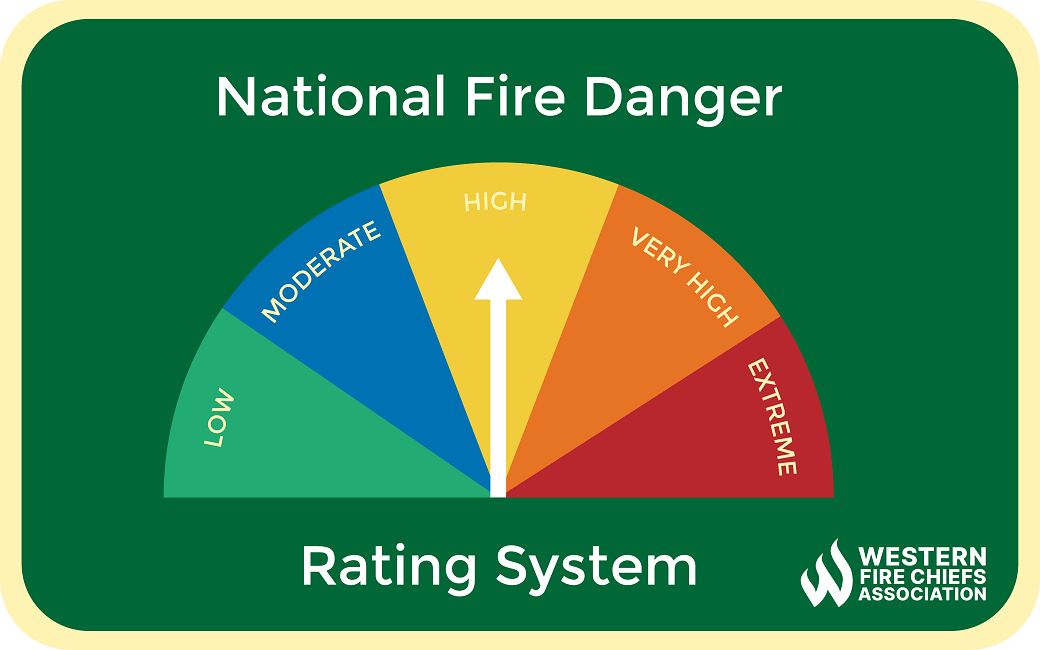
The National Fire Danger Rating System (NFDRS) is a fire assessment system used in the United States to provide a daily estimate of wildfire risk in an area. The NFDRS uses a set of equations with variables that include weather, local topography and fuel types, and humidity to calculate an area’s daily fire danger index.1
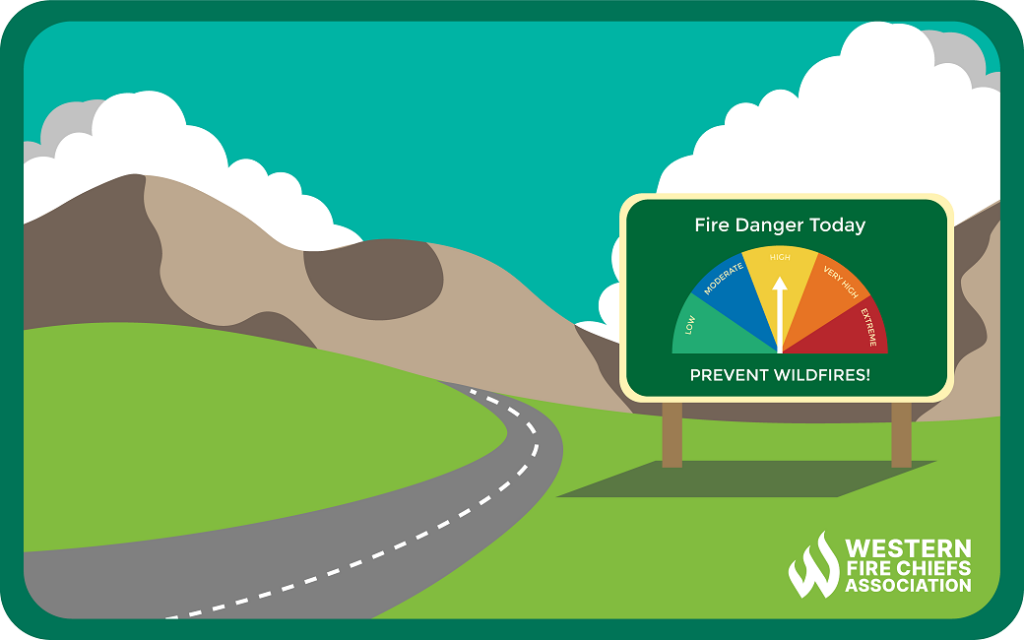
The NFDRS has five levels of fire potential. You may see the levels represented on color-coded dials in parks and wildland areas, with an arrow indicating the fire danger level for the day. These displays help the public understand local wildfire risk based on current weather and environmental conditions.1 Wildland visitors can see if it is safe to have a campfire, forest workers may take extra precautions when using equipment that sparks, and homeowners may postpone burning debris based on the fire danger level for that day.
Fires are unlikely to start under these weather and fuel conditions without intense heat sources. Any fires that start will spread slowly, remain at a low intensity, and be reasonably easy control and extinguish.
Some wildfires may ignite at a moderate size and intensity. Controlling wildfires at this level is not difficult. Light to moderate mop up will be enough to manage these fires. Controlled burns can be performed under these conditions but should be executed cautiously.
Weather and fuel conditions mean that wildfires are likely. Wildfires in areas with heavy, continuous fuel, such as mature grassland, fields, and forest litter, will be hard to control if there are high winds. Directly attacking the fire may be difficult. Careful mop up is essential.
Fires will start easily, and suppression efforts may not be able to keep up with the spread. Flames will be large, intense, and hard to control. Containment, suppression, and mop up will take a lot of work. Outdoor burns are not recommended.
Wildfires can start and spread quickly under these conditions. Any fire has the potential to become huge and uncontrollable. Fire behavior is likely to be extreme and erratic. Hence, there should not be any outdoor burns if fire danger in the area is extreme.
The NFDRS assesses fire risk based on a range of factors, including lightning occurrence, human-caused fires, and Fire Load Index.2 Some of the indexes that contribute to the NFDRS’s process of determining fire risk are useful to understand when considering local fire dangers. The following NFDRS outputs3 help firefighters plan fire suppression strategies and understand regional fire risks.
Ignition Component is the probability of wildfire if a firebrand is introduced into dry, dead fuel. This value ranges from 0 (conditions are cool and damp) to 100 (conditions are dry and windy). For example, on a day when the IC is 40, approximately 40% of all firebrands that meet wildland fuels will require fire suppression.4
This index assesses drought conditions and their effect on fire potential and intensity. Within a range of 0 to 800, it estimates the amount of precipitation (in 100ths of inches) needed to bring 8 inches of soil to saturation. A value of 0 is saturated. Therefore, as KBDI values increase, drought conditions are more severe. KBDI calculations include weather station latitude, average annual precipitation, the maximum air temperature, and the last 24 hours of rainfall.5
This value measures the forward spread of wildfire (in feet per minute) based on wind, slope topography, and fuel properties. Each fuel type requires a specific SC table due to the moisture content variability of fine fuels and living, woody plants.4 There is no upper limit to this scale.2 An example of an SC value of 30 describes fuel and conditions that would burn with a forward rate of spread of 30 feet per minute.
This number quantifies the available energy/potential heat release—in British Thermal Units (BTU) per square foot—at the head of a fire. The ERC value fluctuates with changes in moisture content of the various fuels present. As live and dead fuels dry out, the ERC value rises to reflect drought conditions.2
The Burning Index assesses how fire behavior contributes to fire containment efforts, based on local SC and ERC. It is expressed as a numeric value of flame length in feet multiplied by ten. Fire containment difficulty increases more than twice as quickly as BI values increase. The scale is open-ended and predicts fire line intensities and flame length under worst case-scenario conditions in an area.2
The United States began researching fire danger evaluation around 1922, after major fire events in 1910 demonstrated a need to predict fire activity. Several different systems emerged throughout the 1930-50s, incorporating observed local environmental conditions like temperature, humidity, wind conditions, and amount of combustible material. In 1958, efforts began to standardize and implement a single fire danger rating system throughout the U.S. that would evaluate ignition, fire spread, and fuel energy risks. The first system was the Timber Spread Index, which was tested during the mid-1960’s to limited success.6
In 1968, focus shifted to creating a fire danger rating system using constant scientific principles that could apply anywhere in the U.S. The first version of the NFDRS was released in 1972 as a system of lookup tables.6 Since 1974, the five risk levels and associated colors have been used to describe local wildfire danger to the public.4 Recent advancements in technology and computer software have helped speed up and systematize NFDRS calculations.
Stay safe around the campfire with tips from the Western Fire Chiefs Association. Learn essential precautions and practices for a worry-free outdoor campfire.
Discover essential firework safety tips to ensure a dazzling display without accidents. Learn how to celebrate responsibly with expert guidance from WFCA.
Explore the role of AI in wildfire prediction with guidance from the WFCA. Learn how advanced algorithms and data analytics enhance early detection and response.